
|
|
|
|
Chase Reports Summer 2002/03 Summer 2001/02 Winter 2001 Winter 2000 20/06/00 - Winter chase, 3 Tornadoes Summer 1999/200020/02/00 - Thundery showers in Perth Jan 4-14, 2000 Dust Devil Paradise 24/12/99 - Christmas Eve Chase 29/02/99 - Chase North East, nice storm with gust front 11th,12th,13th/12/99 - Chase's to Perth coast, Bindoon & Toodyay 02/11/99 - Nice chase to the wheatbelt with numerous CB's & some great mammatus Winter 1999 Summer 1998/1999 28/11/98 - Dowerin Tornado & chase Winter 1997/1998 17/04/98 - I chased & saw my first tornado, 2 supercells an awesome wallcloud & 1-2 inch hail Winter 1997 05/09/97 - 5 tornadoes in WA in 36 hours Summer 1996/1997 |
All images © Inflow Images
Chase Report for 10th June 99
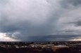
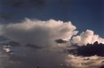
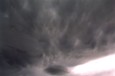
With a low pressure system headed for the WA coast line we usually get some showers out of the convergence line ahead of the front and if conditions are right we can get storms, today was such a day. I had my eye on conditions for a few days and after returning home early from work I checked out he radar to find good storms already going off the coast. Mike Fewings was online and so we decided to head to the coast. We drove to the coast and after some 4wd driving just south of Fremantle we got up onto a nice look out. We could see a few cells just starting out already. The cells were very very slow moving and when they were getting closer to the coastline we left our spot to get right on the coast. We decided to get just south of the cell which had now split into two and we also had new cells developing to our south buy the time we got to the coast. We sat it out here and watched an awesome storm move in over the coast, the show was great! One cell to our south was about 50ks away and was so big that I couldn't fit it in one pic!!! Phone updates from Jacob helped us to know what was on the radar and positioned ourselves on the SW side of the cells. As you probably all know by now, two fellow ASWA members (Greg Spencer and Mark Dwyer) saw and reported funnels/waterspouts. After talking with Barry at the BOM here at least 3 were seen but there may have been more. Myself and Barry aren't 100% sure if they were water spouts or tornadic water spouts, we both agreed that it was certainly border line as there was a weak shear environment around. Another 10-20knts of shear and they would have seen tornadic waterspouts cross the beach and make landfall for sure, we both agreed on that. So unfortunately for us or fortunately for the other guys the funnels were all to the north and rear of the cell, certainly unusual for here. Once we got out there lack of shear was really noticeable but the airplots did show the wind swinging with height just off the coast before we left. Kinda confused me why the spouts were to the north and rear of the cells, we were mostly around just south of freo from lunch time on but moved north later. Storm tops were anviling out at about 8-9k's ( I think ). I saw later that there was a jet at around 10k and some did cap out, at least 2 that I saw, most of the others were close anyway. The cell that crossed at around 4:30ish just north of freo looked awesome from the front!! The rain in it was just black as the ace of spades (we came in from the south side) and Jason Bush also an ASWA member on hols here from up north did get pea sized hail. We came in behind the storm up to freo and there was alot of water lying around. So we missed the waterspouts but not by very far, it was funny cause we could see out past Rotto the whole time, but never saw them. Many thanks from Mike and myself to Jacob for all the updates on the radar. The best storm all day crossed Perth at around 3:20am in the morning, it was small and crappy on the radar but it goes to show that the radar isn't really a good indication of how strong a storm is, the storm did damage in a few perth suburbs and there was an F-0 tornado recorded. At first I wasn't convinced that it was a tornadic event, but what gave me doubt was that if it was just a downdraft, the damage path is very narrow and only about 4 k's long. It's usually hard to get a downburst in a narrow channel like that...also the winds above the surface weren't that strong to mix down in the downdraft. Barry said that over narrow paths he wants to see winds above the surface of at least 60-70knts where as that night we had only 30knts. So the damage must have been caused by rotation, therefore we came to the conclusion that it was a weak F-0 tornado that was skipping along as the damage path is broken and it probably never really got going that good. Barry said that they will record it as a tornado. Its great that another one was recorded simply by someone going out there to investigate the damage path. I also discovered later that the storms had formed due to the usually warm ocean sea surface temps here of the coast of WA.
Less than one week later on the
17th at approx 8:00pm the Perth suburb of Kniwana and Wiakiki was struck by a
tornado. The path was NW-SE and about 50-80m wide. I spoke at length with Barry
Hanstrum of the perth BOM this afternoon and he rated it as an F1, with internal
winds speeds around 150kph. There is mostly fairly minor damage, many trees
uprooted and lots of minor damage to homes but a couple of houses were totally
unroofed. The path length is at least 6 km long. The tornado occurred in a cell
on the front. Those who were online did see the cell on the radar.
Ira Fehlberg
The cells were very very slow moving and when they were getting closer to the coastline we left our spot to get right on the coast. We decided to get just south of the cell which had now split into two and we also had new cells developing to our south buy the time we got to the coast. We sat it out here and watched an awesome storm move in over the coast, the show was great! One cell to our south was about 50ks away and was so big that I couldn't fit it in one pic!!! It dropped heavy rain over Mandurah.
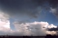
Phone updates from Jacob helped us to know what was on the radar and positioned ourselves on the SW side of the cells. As you probably all know by now, two fellow ASWA members (Greg Spencer and Mark Dwyer) saw and reported funnels/waterspouts. After talking with Barry at the BOM here at least 3 were seen but there may have been more. Myself and Barry aren't 100% sure if they were water spouts or tornadic water spouts, we both agreed that it was certainly border line as there was a weak shear environment around. Another 10-20knts of shear and they would have seen tornadic waterspouts cross the beach and make landfall for sure, we both agreed on that. So unfortunately for us or fortunately for the other guys the funnels were all to the north and rear of the cell, certainly unusual for here. Once we got out there lack of shear was really noticeable but the airplots did show the wind swinging with height just off the coast before we left. Kinda confused me why the spouts were to the north and rear of the cells, we were mostly around just south of freo from lunch time on but moved north later. Storm tops were anviling out at about 8-9k's ( I think ). I saw later that there was a jet at around 10k and some did cap out, at least 2 that I saw, most of the others were close anyway. The cell that crossed at around 4:30ish just north of freo looked awesome from the front!! The rain in it was just black as the ace of spades (we came in from the south side) and Jason Bush also an ASWA member on hols here from up north did get pea sized hail. We came in behind the storm up to freo and there was alot of water lying around. There was another cell further north but the sun was setting and the cell was dieing. We did get treated to a nice sunset though. So we missed the waterspouts but not by very far, it was funny cause we could see out past Rotto the whole time, but never saw them. Many thanks from Mike and myself to Jacob for all the updates on the radar.
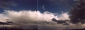
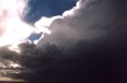
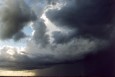
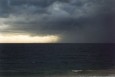
Below is the storm that had the waterspouts and dropped heavy rain and hail at Fremantle. Some nice features on it including mammatus on the anvil as it cam over us, nice solid updraughts, heavy black rain and a gust front.


However the best storm all day crossed Perth at around 3:20am in the morning, it was small and crappy on the radar but it goes to show that the radar isn't really a good indication of how strong a storm is, the storm did damage in a few perth suburbs and there was an F-0 tornado recorded. At first I wasn't convinced that it was a tornadic event, but what gave me doubt was that if it was just a downdraft, the damage path is very narrow and only about 4 k's long. It's usually hard to get a downburst in a narrow channel like that...also the winds above the surface weren't that strong to mix down in the downdraft. Barry said that over narrow paths he wants to see winds above the surface of at least 60-70knts where as that night we had only 30knts. So the damage must have been caused by rotation, therefore we came to the conclusion that it was a weak F-0 tornado that was skipping along as the damage path is broken and it probably never really got going that good. Barry said that they will record it as a tornado. Its great that another one was recorded simply by someone going out there to investigate the damage path. I also discovered later that the storms had formed due to the usually warm ocean sea surface temps here of the coast of WA.
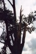
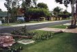
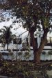
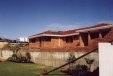
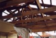
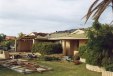
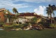
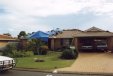
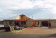
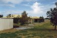
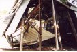
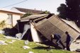
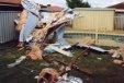
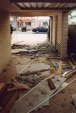
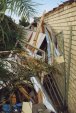
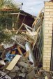
Less than one week later on the 17th at approx 8:00pm the Perth suburb of Kniwana and Wiakiki was struck by a tornado. The path was NW-SE and about 50-80m wide. I spoke at length with Barry Hanstrum of the perth BOM this afternoon and he rated it as an F1, with internal winds speeds around 150kph. There is mostly fairly minor damage although some areas were hit very hard as you can see in the pictures below. Amazing when you look at the damage to think it was only and F-1. Many trees uprooted and lots of minor damage to homes but a couple of houses were totally unroofed. The path length is at least 6 km long. The tornado occurred in a cell on the front. Those who were online at the time did see the cell on the radar. It got extensive media coverage in both the News papers and on TV.
Ira Fehlberg
Damage from the Tornado path in Rockingham